Bayfield Regional Conservancy
  • Home
  • What We Do
    • Where We Work >
      • Strategic Conservation Plans
    • Preserve Your Land >
      • Private Land Preservation
      • Farmland Preservation
      • Land & Water Preservation
      • Start an Easement
    • Trails & Public Land Preservation >
      • Big Ravine and Nature Trail >
        • Big Ravine - Upper Section Management Plan
      • Brownstone Trail
      • Cornucopia Beach
      • Frog Bay Tribal National Park
      • Gil Larsen Nature Trail
      • Houghton Falls Nature Preserve
      • Jerry Jay Jolly Trails
      • Lincoln Community Forest >
        • Lincoln Community Forest management plan
        • Lincoln Community Forest MFL plan
      • Lost Creek Bog State Natural Area
      • Mt. Ashwabay
      • Nourse Sugarbush State Natural Area
      • White River Fisheries Area
      • North Pikes Creek Wetlands Community Forest >
        • North Pikes Creek Beaver Trapping Permit
        • NPC Presentation June 2025
        • North Pikes Creek Management Plan
    • Siskiwit River Estuary Preserve Project
    • Tyler Forks Community Forest Project
    • Geocaching
    • Northern WI Sasquatch Preserve
    • Other Initiatives & Partnerships
  • How You Can Help/Donate
    • Donate
    • Monthly Giving
    • Become a Legacy Society Member
    • Other Ways to Give
    • Volunteer With Us
    • Native Plants
  • About BRC
    • Accreditation Renewal
    • Contact Us
    • Join the Mailing List
    • Staff >
      • Join Our Team
    • Board >
      • BOARD/STAFF ONLY
    • BRC History
    • Annual Reports
    • Strategic Plan
    • Meet Our Partners
  • What's Happening
    • Native Plant Sale 2025
    • Event Calendar
    • BRC "In the News"
    • Newsletter Archive
  • Store

Frog Bay Tribal National Park

  • el
  • pt
  • "The holy land is everywhere"
    -Chief Black Elk
    donate

                           Frog Bay Tribal National Park

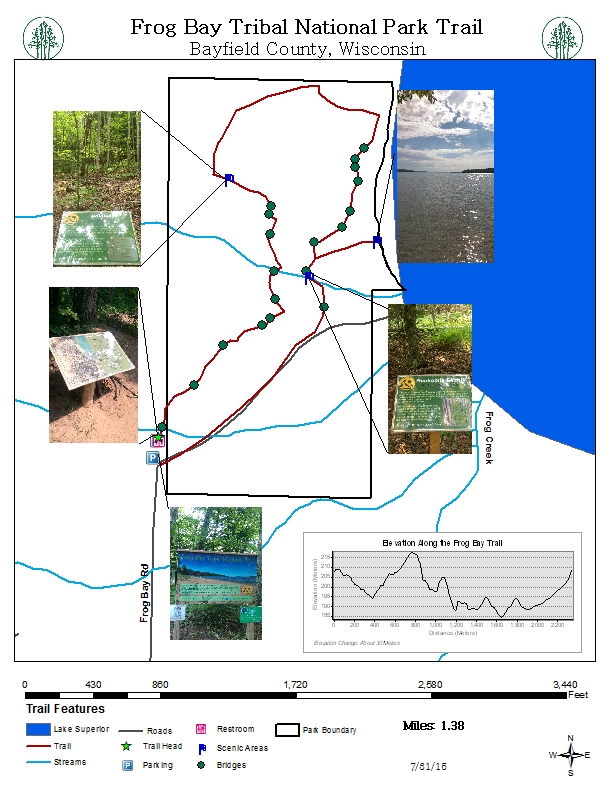
    Distance: 1.5 miles
    Trail Difficulty: Beach .5 mile - Easy, Ravine 1 mile - Moderate
    Owned/managed by the Red Cliff Band of Lake Superior Chippewa​
    Map

    Stretching over .25 mile along Lake Superior’s shoreline on the Red Cliff Band of Lake Superior Chippewa Reservation, this incredible 88-acre property includes pristine sandy beaches bordered by primordial boreal forest identified to be of Global Significance by the Wisconsin Department of Natural Resources. The trail provides excellent views of the Apostle Islands Gaylord Nelson Wilderness Area including Oak, Basswood, Hermit, Raspberry and Stockton Islands. 

    This property was protected through a partnership with private landowners, BRC, the Red Cliff Tribe, and funders. The Conservancy worked with David and Marjorie Johnson who purchased the land in the 1980’s to ensure its permanent protection with the Johnson’s donating half of the value of the land. The remaining half came in the form of a Coastal Estuarine Land Conservation Program grant from the National Oceanic and Atmospheric Agency.

    Directions: From Bayfield, drive North on Hwy 13 to Red Cliff. Turn right on Blueberry Rd. at Legendary Waters Resort & Casino. Follow Blueberry Rd. for approx. 3 miles. Turn right onto Frog Bay Rd. Follow until it dead ends. The Ravine Trail can be reached via the beautiful metal bridge to the left or the Beach Trail via an old access road to the right of the parking area. 

    Geocache
    GC5ZP9Y —N 46° 54.598, W 090° 47.161 

    Proudly powered by Weebly
    • Home
    • What We Do
      • Where We Work >
        • Strategic Conservation Plans
      • Preserve Your Land >
        • Private Land Preservation
        • Farmland Preservation
        • Land & Water Preservation
        • Start an Easement
      • Trails & Public Land Preservation >
        • Big Ravine and Nature Trail >
          • Big Ravine - Upper Section Management Plan
        • Brownstone Trail
        • Cornucopia Beach
        • Frog Bay Tribal National Park
        • Gil Larsen Nature Trail
        • Houghton Falls Nature Preserve
        • Jerry Jay Jolly Trails
        • Lincoln Community Forest >
          • Lincoln Community Forest management plan
          • Lincoln Community Forest MFL plan
        • Lost Creek Bog State Natural Area
        • Mt. Ashwabay
        • Nourse Sugarbush State Natural Area
        • White River Fisheries Area
        • North Pikes Creek Wetlands Community Forest >
          • North Pikes Creek Beaver Trapping Permit
          • NPC Presentation June 2025
          • North Pikes Creek Management Plan
      • Siskiwit River Estuary Preserve Project
      • Tyler Forks Community Forest Project
      • Geocaching
      • Northern WI Sasquatch Preserve
      • Other Initiatives & Partnerships
    • How You Can Help/Donate
      • Donate
      • Monthly Giving
      • Become a Legacy Society Member
      • Other Ways to Give
      • Volunteer With Us
      • Native Plants
    • About BRC
      • Accreditation Renewal
      • Contact Us
      • Join the Mailing List
      • Staff >
        • Join Our Team
      • Board >
        • BOARD/STAFF ONLY
      • BRC History
      • Annual Reports
      • Strategic Plan
      • Meet Our Partners
    • What's Happening
      • Native Plant Sale 2025
      • Event Calendar
      • BRC "In the News"
      • Newsletter Archive
    • Store
    ✕