- Home
-
What We Do
- Where We Work >
- Preserve Your Land >
-
Trails & Public Land Preservation
>
- Big Ravine and Nature Trail >
- Brownstone Trail
- Cornucopia Beach
- Frog Bay Tribal National Park
- Gil Larsen Nature Trail
- Houghton Falls Nature Preserve
- Jerry Jay Jolly Trails
- Lincoln Community Forest >
- Lost Creek Bog State Natural Area
- Mt. Ashwabay
- Nourse Sugarbush State Natural Area
- White River Fisheries Area
- North Pikes Creek Wetlands Community Forest >
- Siskiwit River Estuary Preserve Project
- Tyler Forks Community Forest Project
- Geocaching
- Northern WI Sasquatch Preserve
- Other Initiatives & Partnerships
- How You Can Help/Donate
- About BRC
- What's Happening
- Store
|
Gil Larsen Nature Trail/Iron Bridge Trail
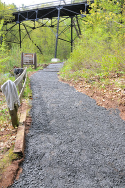
Distance: .75 miles Trail Difficulty: Easy Owned/managed by City of Bayfield Map This quaint trail follows the Big Ravine Forest’s stream under an old iron bridge to an overlook. This trail's namesake, Gilbert Larsen, grew up near the ravine and harbored a life-long interest in the wise use and management of natural resources as a conservationist. The trail offers a first-hand look at conservation as the trees have regrown following the ravine flood of 1942. Directions: Travel uphill from the ferry-boat landing on Washington Avenue in Bayfield. You’ll see the Iron Bridge and parking area on your right. Trail starts at the sign near the parking area. |
Proudly powered by Weebly
- Home
-
What We Do
- Where We Work >
- Preserve Your Land >
-
Trails & Public Land Preservation
>
- Big Ravine and Nature Trail >
- Brownstone Trail
- Cornucopia Beach
- Frog Bay Tribal National Park
- Gil Larsen Nature Trail
- Houghton Falls Nature Preserve
- Jerry Jay Jolly Trails
- Lincoln Community Forest >
- Lost Creek Bog State Natural Area
- Mt. Ashwabay
- Nourse Sugarbush State Natural Area
- White River Fisheries Area
- North Pikes Creek Wetlands Community Forest >
- Siskiwit River Estuary Preserve Project
- Tyler Forks Community Forest Project
- Geocaching
- Northern WI Sasquatch Preserve
- Other Initiatives & Partnerships
- How You Can Help/Donate
- About BRC
- What's Happening
- Store
